
The Town of Milton is responsible for:
-
Emergency preparedness and services
-
Road drainage
-
Stormwater management
-
Land-use planning and zoning
-
Parks and trails
-
Tree canopy management
Welcome to our new website!
↓Overview
↓What is flood hazard mapping
↓Updated flood hazard mapping
↓Flood hazard mapping and property owners
↓Roles in flood mitigation
↓How this information affects you
Flood hazard mapping helps identify areas that may be at risk of flooding during extreme weather events. This information supports safer land-use planning, emergency preparedness, and flood risk reduction across Milton.
This page explains what flood hazard mapping is, how updated mapping is developed, how it may affect property owners, and the roles different organizations play in flood mitigation.
Flood hazard mapping uses advanced computer-generated models to predict where flooding may occur. Flooding happens when water levels in rivers or streams overflow their banks onto neighbouring land.
Flood hazard maps identify flood hazard areas—locations where flooding has already occurred or is expected to occur under extreme storm conditions.
These maps help guide planning decisions and emergency response efforts.
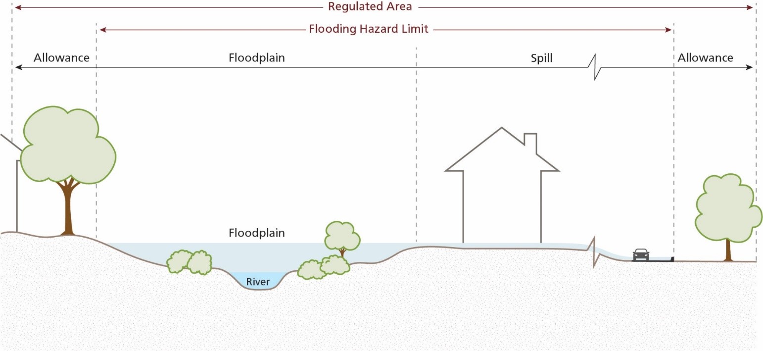
Riverine flood hazards. Diagram by Conservation Halton.
Flood hazard mapping in Milton is periodically updated to reflect new data and improved modelling.
In 2019, Conservation Halton updated flood hazard modelling and mapping for the West Branch of Sixteen Mile Creek, focusing on existing urban areas in Milton. The updated mapping uses current data and tool to better understand flood risks. Information about the mapping is available on Conservation Halton’s website.
Flood hazard mapping is an important tool for land-use planning and development. Properties located within mapped flood hazard areas may be subject to development limitations or restrictions.
If your property is located in a flood hazard area, it may be at risk of river flooding during extreme storm events. Under these conditions:
Conservation Halton regulates development
Activities within flood-prone areas may require review or approval
Providing mapping information helps Conservation Halton:
Advise property owners about flood risks
Identify opportunities for floodproofing and mitigation
Support informed decisions about land use and development
For property-specific information, it is best to consult with the Town and Conservation Halton before submitting an application.
Flood mitigation is a shared responsibility. The organizations and groups below each play a role in reducing flood risk and supporting community safety.
The Town of Milton is responsible for:
Emergency preparedness and services
Road drainage
Stormwater management
Land-use planning and zoning
Parks and trails
Tree canopy management
Regional municipality (Halton Region)
Halton Region plays a role in:
Emergency management
Flood prevention and recovery
Basement flooding subsidy programs
Regional infrastructure
Water quality
Conservation authority (Conservation Halton)
Conservation Halton is responsible for:
Natural hazard mapping and modelling
Flood forecasting and warning
Flood control infrastructure
Natural hazard and wetland regulations
Residents can help reduce flood risk by:
Understanding whether their property is susceptible to flooding
Making plans to protect themselves and their property
Preparing an emergency kit with supplies for at least 72 hours